Trip Highlights:
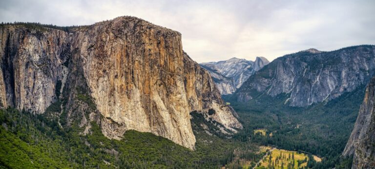
We begin our Glacier Point hike by taking the shuttle/tour bus from Yosemite Valley to Glacier Point. After viewing the high country from Glacier Point, we descend back to the Yosemite Valley along the Panorama and Mist trails. Awesome viewpoints of the Yosemite Valley throughout! You will pass beside three large waterfalls on this epic return hike to Yosemite Valley. Total mileage is 8.5 miles with a 4,113' feet elevation loss and 941' elevation gain.
NOTE: Your group can also decide to return to the Yosemite Valley via the 4-mile trail (actually 4.8-miles). This shorter, moderate-to-strenuous downhill trek offers grand views of the Yosemite Valley and the Merced River.
NOTICE: We can only run this trip based on the park concessionaire's bus availability and schedule, which usually begins in early May (plus/minus depending on the snowpack from the winter prior).
All Tours Are Private
You will receive a full refund if you cancel within 48 hours of the original booking date.
Book with confidence, knowing you can cancel for any reason 30 days before your trip date and receive a full, lifetime, transferable credit.
Not sure if your current trip dates work? Rest assured, you can change your trip date as many times as needed, provided you do so 30 days before both the current and the new trip dates, subject to our guide’s availability.
Meeting Location: Yosemite Valley Lodge at 3,973′
High Point: Glacier Point at 7,214′
Elevation Gain & Loss: +941′, -4,113′
Start your full-day tour at Yosemite Lodge, located across from Yosemite Falls, where you’ll meet your guides in the morning. From here, hop on a shuttle bus to Glacier Point and listen to informative narration about Yosemite National Park during the 1-hour ride.
Your hike begins at Glacier Point, where you are treated to iconic views of prominent landmarks such as Half Dome and Cloud’s Rest, as well as three waterfalls: Yosemite Falls, Vernal Fall and Nevada Fall. Your guides discuss the historical significance of the viewpoint and other park features while you have plenty of photo opportunities.
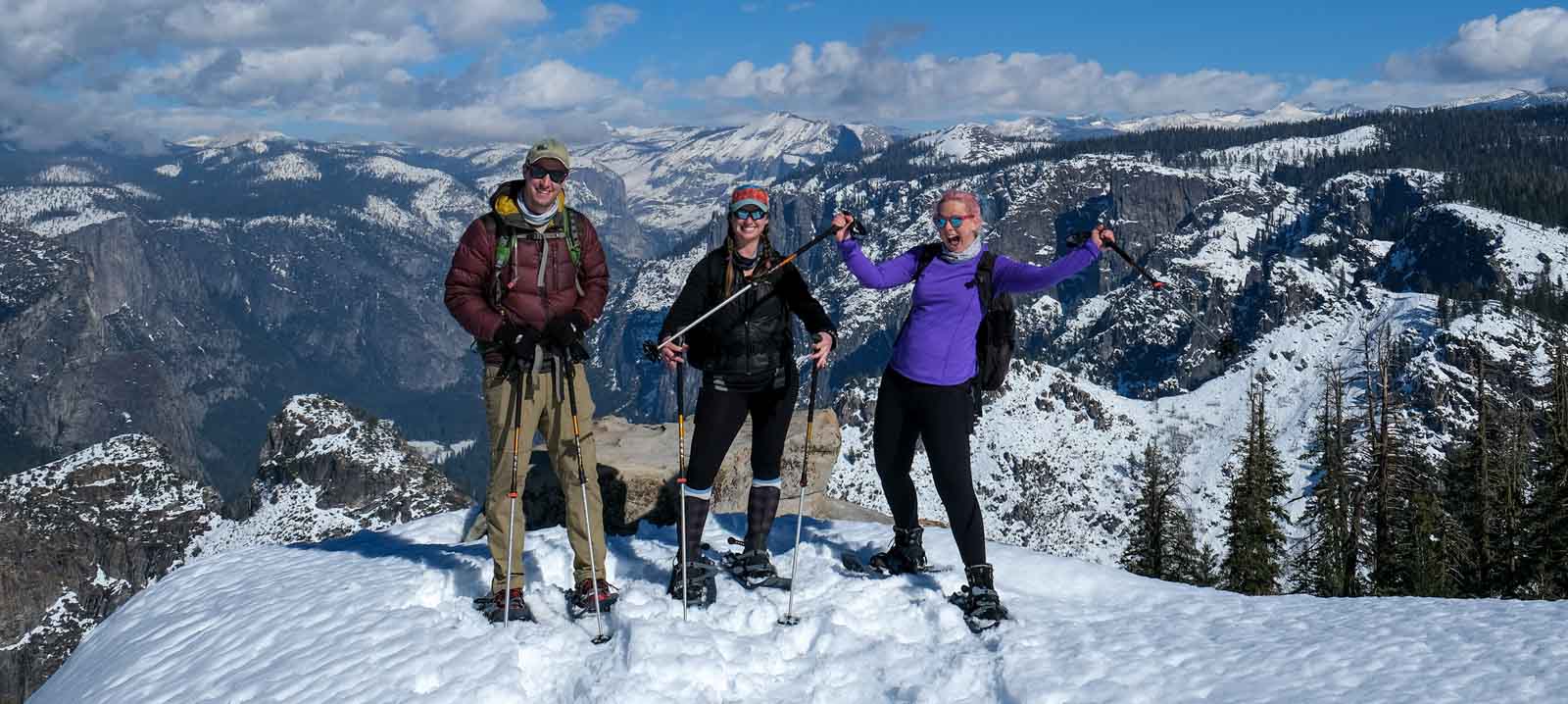
Then, follow a guide on foot along mostly downhill terrain that takes you on a scenic 8.5-mile (13.7-km) route with a total 3,179-foot (969-meter) elevation loss; you’ll have breaks to refuel. Your first 1.5-mile (2.4-km) push descends 800 vertical feet (244 meters) in elevation to the top of the 370-foot (113-meter) Illilouette Fall, where you can catch your breath before continuing your hike.
The next 1 to 1.5 miles (1.6 to 2.4 km) takes your small group up a moderately strenuous section of switchbacks that ascend about 300 vertical feet (91 meters). Once the switchbacks are conquered, the trail flattens out for an easy and scenic 1 to 1.5 miles to the next junction — the Panorama Trail.
Running along this eastern point in the valley, the Panorama Trail offers postcard-worthy views that live up to its name. The following mile — a strenuous downhill series of 20 or so switchbacks — drops you 700 feet (213 meters) in elevation to the outflow of Nevada Fall.
After a lunch break atop the 594-foot (181-meter) waterfall, continue with your guides on one of two trails, depending on your group’s preference. A less strenuous 3.5-mile (5.6-km) trek down the John Muir Trail offers higher vantage points with views of Nevada and Vernal falls, as well as of Half Dome’s south face and the abrupt uprising of Liberty Cap. Or, opt for a slightly shorter route of 2.5 miles (4 km) down the granite staircases of the Mist Trail, which runs alongside the scenic Merced River and its 594-foot Nevada Fall and 317-foot (97-meter) Vernal Fall.
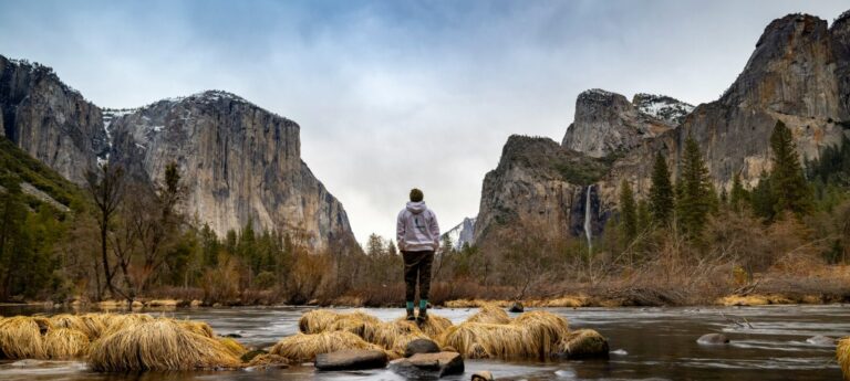
Both trails lead to restrooms and running water near the footbridge at the base of Vernal Fall. From here, it’s about a 1-mile downhill hike on a steep, paved trail to Happy Isles, where you catch a shuttle bus back to Yosemite Lodge before you bid farewell to your guides.
Your participation helps sustain our non-profit mission of supporting youth, families, and disadvantaged communities with positive experiences in America’s National Parks and natural spaces.
Yes, we book all of our Day Hikes as private and do not have an option to join a group. The only exception is our Half Dome in a Day hike in Yosemite, which allows up to 5 guests and 1 guide per trip.
Unfortunately, no, we do not schedule half-day tours. However, as every Day Hike is private, you can modify and customize your day with the guide as needed upon meeting and/or throughout the tour. For example, if you need (or prefer) to end at a specific time, just let the guide know when you meet, and they can make that happen.
Yes, and lucky you, as you will have a private guide for that day.
Yes, see here for our Day Hike Equipment List.
Our Guides will supply trekking poles, the gloves for Half Dome cables, and will also carry first-aid supplies and water purification devices for water along the way. They also carry bathroom supplies (toilet paper, trowel, hand sanitizer), bug repellent, suntan lotion, and they are always armed with fun, natural facts and stories from the park.
No, and we suggest you bring your own trail lunch, snacks, and full water bottles.
Yes, parking is always available at our meeting point, and your vehicle can remain there throughout the day.
Although past clients have said they were glad they rented a vehicle, there are limited public transportation options for most of the trips we offer in Yosemite. See here for additional information: Yosemite Transportation Options.
See our Day Hike Cancellation Policy on our Terms and Conditions Page, which is summarized below:
Availability